The ports
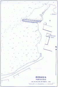
Bonagia
Bonagia, the harbor and the surrounding ! Receptions: Years. 38° 04′ North – Long. 12° 35′ East Maritime Authority: Delegation of beach chorography Located in the western part of the Gulf and about m. 5 NE of Trapani, the small port of Bonagia moiette breakwater consists of a quay no longer m. …
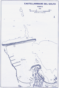
Castellammare del Golfo
The port of Castellammare del Golfo Location: Years. 30° 02′ North – Long. 12° 53′ East Maritime Authority: beach delegation COROGRAPHY Located almost in the center of the Gulf of Castellammare, which lies between Cape S. Vito and Punta Raisi, the port of Castellammare del Golfo is located midway between the port …

Favignana
Favignana, the harbor and the island ! favignana@castellammaredelgolfo.com Favignana geographical position and its goal: Years. 37° 56′ North – Long. 12° 19′ East Maritime Authority: Delegation of beach Tel.922273 chorography is the only port of the same name, the largest of the Egadi. It is located near the center of the coast exposed to NE in the inlet named Cala Main, …
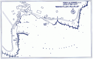
Levanzo
Levanzo, the harbor and the island ! Receptions: Years. 37° 59′ North – Long. 12° 20′ East Maritime Authority: The Delegation of beach chorography Levanzo port is located on the southern coast of the same name, the smallest of the Egadi in Trapani and the nearest, which is 7 miles. It is derived from …
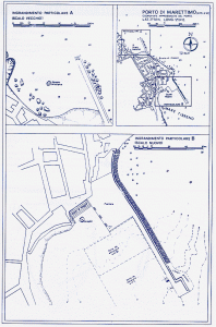
Marettimo
Marettimo, the harbor and the island ! Marettimo: fishermen at the harbor Location: Years. 37° 58′ North – Long. 12° 04′ East Maritime Authority: Delegation of beach chorography The port of Marettimo, only inhabited island of the same name, which is the farthest from Sicily Egadi, is actually composed of two small pier called Scalo …
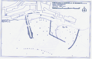
Marinella di Selinunte
The small harbor of Selinunte Marinella Marinella Location: Years. 37° 35′ North – Long. 12° 50′ East Maritime Authority: Delegation of beach SYSTEMS AND SERVICES Bunkering (up area), search and rescue, health service, technical services, PP.TT., phones, banking service, tourist service. Chorography Located midway between the ports of Mazara del Vallo …
Marsala
Marsala – The Port and the city ! Marsala: After the marina was destroyed by the Syracusans Mozia (378 a. C.), Phoenician colony on the Gulf Stagnone, an 'other naval base, Lilybaeum, established just to the south of the first, on the promontory of the same name, established itself as a trading center and became one of …
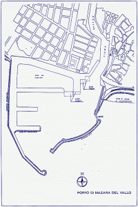
Mazara del Vallo
The port of Mazara del Vallo Location: Years. 37°40’00” N – Long. 12°34’30” And Maritime Authority: Port authorities (Such.0923-946388) Chorography Overview of the port The port is divided in harbor and port again; the backgrounds of both have been excavated at -6 m. with the exception of a small area indicated as “dry …
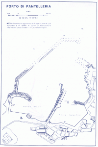
Pantelleria
Pantelleria, the harbor and the island ! Receptions: Years. 36° 47′ North – Long. 12° 59′ East Maritime Authority: Local Office of Maritime Street S. Nicola, 1 – Such.0923/911027 It includes 4 Whether quay length of about m. 75 the southern; m. 55 the one at W; m. 40 tract in the NW and m. …
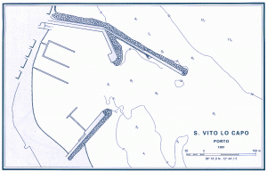
San Vito lo Capo
San Vito lo Capo, the port and country ! info@sanvitolocapo.biz San Vito lo Capo occupies a promontory (the “Head”) north-western Sicily that separates the Gulf of Castellammare from the coast of Trapani, near the Zingaro nature reserve to the west and east of Mount Hood. See a trap no longer active since …
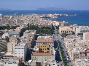
Trapani
Trapani – The Port and the city ! Ancient Phoenician port, said Darbase (Aculeo) and then Drepanon (sickle) from the tongue of land that protects the natural harbor, strategic point of the Mediterranean, it was after the Phoenicians, later in the power of Trojans, Greeks, Carthaginians, the latter of which built an arsenal. In 241 a.C., after various events, …
Welcome to Castellammare del Golfo, Click on the little fish !
") CASTELLAMMARE
CASTELLAMMAREHiking and Trekking, contact: